
We work with diverse groups of public and private partners to improve riparian habitat, instream habitat, landscape conditions and recreational opportunities in our watersheds.


Wallowa River Restoration Project - McDaniel Ranch
Doug McDaniel, a fifth generation Wallowa County resident and founding member of Wallowa Resources, initiated his quest to restore fish habitat along a stretch of the Wallowa River running through his ranch in Lostine in the early 1990’s. After years of frustration in the permitting process, a team consisting of Wallowa Resources, Grande Ronde Model Watershed, Oregon Department of Fish and Wildlife and the Confederated Tribes of the Umatilla Indian Reservation helped McDaniel realize his vision in 2005. Steelhead and later Chinook salmon have spawned annually in the newly constructed channel since the spring of 2006. Efforts like Doug’s and other landowners along the Wallowa and Lostine Rivers have also aided in the return of Coho salmon to the region for the first time in 40 years.

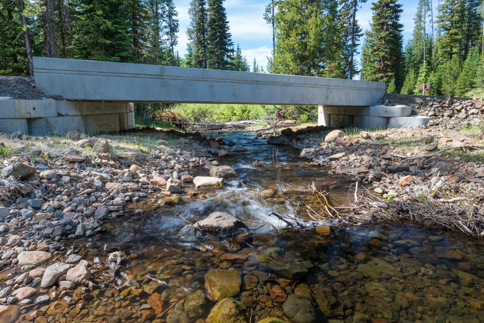
Lick Creek Culvert Replacement
In 2017, our largest watershed restoration project was the replace of a failing culvert on Lick Creek at the FR 3925-015 crossing. This culvert was identified as a barrier to juvenile salmonids by the Nez Perce Tribe. It blocked access to 2.5 miles of spawning and rearing habitat for steelhead; 1 mile of rearing habitat for juvenile spring Chinook salmon, 5 miles of spawning and rearing habitat for bull trout, and an estimated 2.5 miles of spawning and rearing habitat for Pacific lamprey.
With financial support from BPA, OWEB and USFS – we contracted with Henderson Logging LLC to replace the culvert with a 40-foot-span concrete bridge, and construct a new stream channel with additional pool structures and large wood debris to enhance existing channel complexity and habitat. During the after project review, representatives from the USFS praised the work, stating it was “one of the best culvert replacement project that [they’ve] seen in the last 15 years”.
Upper Wallowa River Restoration

The Upper Wallowa River Restoration Project encompasses 1 1/2 miles of the Wallowa and West Fork Wallowa rivers, beginning near the confluence of BC Creek and flowing into Wallowa Lake. This section of the river is primarily managed for recreation with a mix of private and public land including Wallowa Lake State Park. As a large tourist attraction, the area is important to Wallowa County's economy.
The combined habitat and social benefits provide a profound opportunity to showcase a constructive win/win example for the coexistence of people and nature. Additional project partners include the Nez Perce Tribe, ODFW, and OPRD.
This Project will:
•Enhance and restore habitat for Kokanee, bull trout and Sockeye salmon once the Wallowa Lake Damn is rebuilt to allow for fish passage
•Improve habitat while protecting public and private property
•Capitalize on project location to provide environmental outreach to > 500,000 park visitors per year and local youth through Wallowa Resources outdoor education program


Upper Joseph Creek
The upper Joseph Creek area covers 174,000 acres of federal and private land. Crow, Elk and Chesnimnus Creek are the main drainages, which provide critical habitat to steelhead. Upper Joseph Creek contains open prairies, dense forest, and lush creek sides. Opportunities abound to see elk grazing, hear songbirds singing, wonder at wildflowers blooming, and see raptors soaring.
It is also a working landscape, with century-old ranches and livestock operations, small-scale logging and fuel reduction, and habitat work. This land has been used continuously for 8,000 years, starting with the Nez Perce Tribe.
A diverse group worked together to assess Upper Joseph Creek in four aspects: riparian (the area around lakes & rivers), rangeland, forest & fuels, and roads & recreation. Based on this information, the group made recommendations for improving habitat and natural functions. These improvement projects created jobs as well.
Riparian
Flaws in past projects and poorly maintained roads and culverts combined to block steelhead and salmon access to upstream habitat. Alongside local partners, we removed fish barriers and restored natural channel flow to over 32 miles of the Doe, Elk, and Chesnimnus creeks.
Rangeland
A majority of Upper Joseph Creek is working rangeland. Maps were created to classify and assess fences, water developments, and invasive plants. Based on this work, we carried out projects that improved animal production and distribution and relieved livestock pressure around lakes and rivers.
Forest & Fuels
Our forests evolved with disturbance such as fire, which maintains diversity and favors trees like Ponderosa Pine, Douglas Fir, and Western Larch. Past practices, such as overstory logging and fire suppression, have altered our forest. Today, we have dense stands of Grand Fir. Dense stand increase wildfire risk - both the frequency and intensity. By combining prescribed burns and tree thinning/harvesting, we improved habitat in Upper Joseph Creek.
Roads & Recreation
Over 815 miles of road crisscross Upper Joseph Creek at a density of over 2.5 miles of road per square mile, which exceeds the US Forest Service's standards. Due to budget decreases, the US Forest Service is struggling to maintain this vast road network. However, this road access is valuable to ranchers, hikers, hunters, campers, firewood cutters, loggers, and the Nez Perce Tribe. After reviewing the entire road network, we repaired bridges and roads, and installed gates for seasonal road closures. The biggest project removed 28 culverts, which improved road conditions and fish habitat.